You Ask, We Answer
We’re technical experts in the complex and ever-changing world of civil and structural engineering design and technical approval.
What can you build in a Flood Zone?
Our advice is based on the Link team’s collective experience, which includes involvement in hundreds of projects of varying scales from inception through to construction on site, across the UK over the past 15 years. It should be highlighted that each site should be assessed against its own merits and risks to provide the most appropriate flood risk mitigation and most suitable development for each location,
Before we answer what you can build in each Flood Zone, let’s look at what Flood Zones are, and what their significance is in planning terms.
What is a Flood Zone?
The Environment Agency (EA) developed the Flood Zones (FZ) map to show the probability of a river and sea flooding across England. FZ maps do not cover risk of flooding from other sources such as surface, artificial etc and exclude the effect of flood defences.
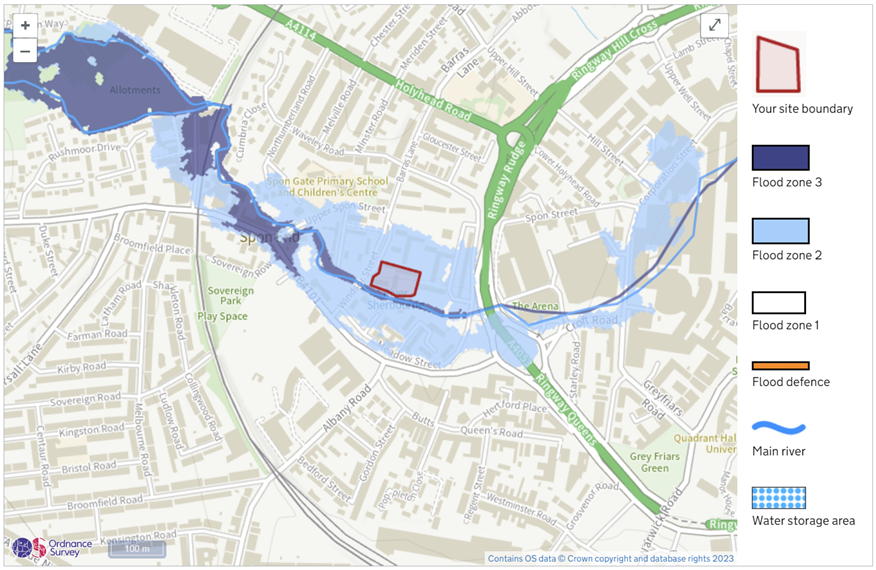
Figure 1. A Development located in FZ2 taken from Flood Map for Planning
Types of Flood Zone
The EA has categorised and provided the definition for each type of FZ in Table 1 of the Flood risk and coastal change guidance.
Table 1. Flood Zones
| Flood Zone | Definition |
| Zone 1 (Low Probability) | Land having a less than 0.1% annual probability of river or sea flooding. (All land outside Zones 2, 3a and 3b). |
| Zone 2 (Medium Probability) | Land having between a 1% and 0.1% annual probability of river flooding; or land having between a 0.5% and 0.1% annual probability of sea flooding. (Land shown in light blue on the Flood Map) |
| Zone 3a High Probability | Land having a 1% or greater annual probability of river flooding; or Land having a 0.5% or greater annual probability of sea. |
| Zone 3b The Functional Floodplain | This zone comprises land where water from rivers or the sea has to flow or be stored in times of flood. The identification of functional floodplain should take account of local circumstances and not be defined solely on rigid probability parameters. Functional floodplain will normally comprise: • Land having a 3.3% or greater annual probability of flooding, with any existing flood risk management infrastructure operating effectively; or • Land that is designed to flood (such as a flood attenuation scheme), even if it would only flood in more extreme events (such as 0.1% annual probability of flooding). Local planning authorities should identify in their Strategic Flood Risk Assessments areas of functional floodplain and its boundaries accordingly, in agreement with the Environment Agency. (Not separately distinguished from Zone 3a on the Flood Map) |
What can you build in each Flood Zone?
Now that we have identified what is a Flood Zone and the types of it, the below tables should make more sense.
We can identify what can and cannot be developed in each flood zone using Table 2 Flood risk vulnerability and flood zone ‘incompatibility’ from EA’s Flood risk and coastal change guidance.
The definition of the development classifications (Essential infrastructure, Highly vulnerable etc.) is given in the National Planning Policy Framework Annex 3: Flood risk vulnerability classification and in Table 3 below.
Table 2. Flood risk vulnerability and flood zone ‘incompatibility’
| Essential infrastructure | Highly vulnerable | More vulnerable | Less vulnerable | Water compatible | |
| Zone 1 | Yes | Yes | Yes | Yes | Yes |
| Zone 2 | Yes | Exception Test required | Yes | Yes | Yes |
| Zone 3a† | Exception Test required† | No | Exception Test required | Yes | Yes |
| Zone 3b* | Exception Test required* | No | No | No | Yes* |
Key:
- Exception test is not required
- Development should not be permitted
† In Flood Zone 3a essential infrastructure should be designed and constructed to remain operational and safe in times of flood
* In Flood Zone 3b (functional floodplain) essential infrastructure that has passed the Exception Test, and water-compatible uses, should be designed and constructed to:
- Remain operational and safe for users in times of flood;
- Result in no net loss of floodplain storage; and
- Not impede water flows and not increase flood risk elsewhere.
*The Exception Test will be covered in more detail in a future post, subscribe to our newsletter to get notified. In the meantime, find more information about the Exception Test here.
Table 3. Annex 3: Flood risk vulnerability classification
| Classification | Description |
| Essential infrastructure | Essential transport infrastructure (including mass evacuation routes) which has to cross the area at risk.Essential utility infrastructure which has to be located in a flood risk area for operational reasons, including infrastructure for electricity supply including generation, storage and distribution systems; including electricity generating power stations, grid and primary substations storage; and water treatment works that need to remain operational in times of flood.Wind turbines.Solar farms. |
| Highly vulnerable | Police and ambulance stations; fire stations and command centres; telecommunications installations required to be operational during flooding.Emergency dispersal points.Basement dwellings.Caravans, mobile homes and park homes intended for permanent residential use.Installations requiring hazardous substances consent. (Where there is a demonstrable need to locate such installations for bulk storage of materials with port or other similar facilities, or such installations with energy infrastructure or carbon capture and storage installations, that require coastal or water-side locations, or need to be located in other high flood risk areas, in these instances the facilities should be classified as ‘Essential Infrastructure’.) |
| More vulnerable | HospitalsResidential institutions such as residential care homes, children’s homes, social services homes, prisons and hostels.Buildings used for dwelling houses, student halls of residence, drinking establishments, nightclubs and hotels.Non–residential uses for health services, nurseries and educational establishments.Landfill* and sites used for waste management facilities for hazardous waste.Sites used for holiday or short-let caravans and camping, subject to a specific warning and evacuation plan. |
| Less vulnerable | Police, ambulance and fire stations which are not required to be operational during flooding.Buildings used for shops; financial, professional and other services; restaurants, cafes and hot food takeaways; offices; general industry, storage and distribution; non-residential institutions not included in the ‘more vulnerable’ class; and assembly and leisure.Land and buildings used for agriculture and forestry.Waste treatment (except landfill* and hazardous waste facilities).Minerals working and processing (except for sand and gravel working).Water treatment works which do not need to remain operational during times of flood.Sewage treatment works, if adequate measures to control pollution and manage sewage during flooding events are in place.Car parks. |
| Water compatible | Flood control infrastructure.Water transmission infrastructure and pumping stations.Sewage transmission infrastructure and pumping stations.Sand and gravel working.Docks, marinas and wharves.Navigation facilities.Ministry of Defence installations.Ship building, repairing and dismantling, dockside fish processing and refrigeration and compatible activities requiring a waterside location.Water-based recreation (excluding sleeping accommodation).Lifeguard and coastguard stations.Amenity open space, nature conservation and biodiversity, outdoor sports and recreation and essential facilities such as changing rooms.Essential ancillary sleeping or residential accommodation for staff required by uses in this category, subject to a specific warning and evacuation plan. |
Maximising the value of sites within Flood Zones
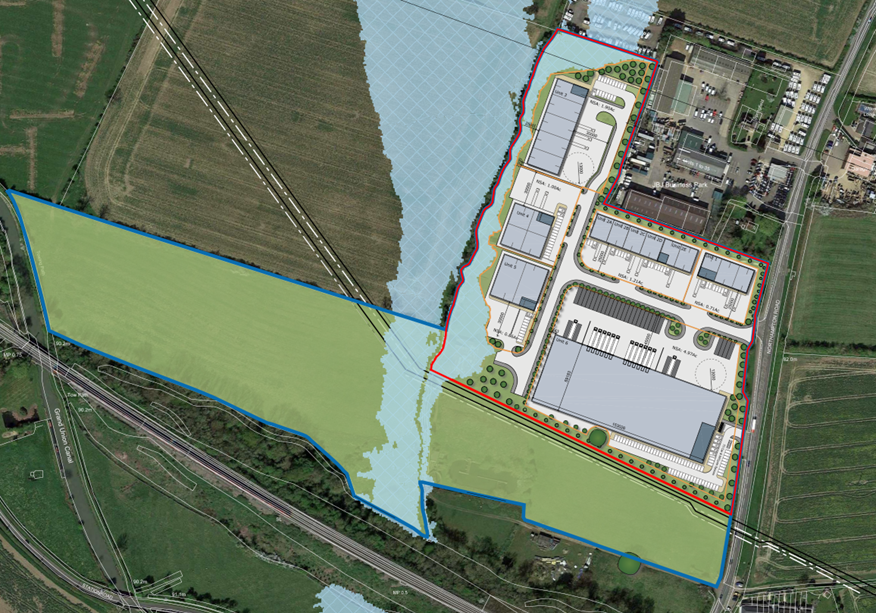
If a site is partially located within FZ3 and the majority in FZ1, the following approach can be taken:
- Avoid any structures within FZ3 areas (if feasible) and ensure any development in FZ1 has mitigation measures in place (e.g. levels set 600mm higher than the FZ3 flood level) and assign low risk development proposals (POS, landscaping) to areas of higher flood risk.
- If the proposed structures are required to be in FZ3, then the FFL needs to be higher than the FZ3 flood level which will usually result in raising the existing ground to tie-in to the proposed structure. This will likely reduce the existing floodplain storage volume and as a developer you will have to provide “level for level” flood compensation to mitigate the loss of floodplain storage.
- Consider completing detailed hydraulic modelling to better define and control the position and extents of Flood Zones to better support the development proposals.
An example of point A can be seen below, where buildings were located to avoid the extent of FZ3.
To review whether you are allowed to develop in a flood zone you would have to look at the above tables as discussed above. However, we felt this could be simplified into one table and make it easier to quickly assess whether you are allowed to develop within a flood zone.
You can download the combined table by clicking here.
Table 4. Combination of Table 2 & Annex 3
| Development Type | Zone 1 | Zone 2 | Zone 3a | Zone 3b |
| Flood control infrastructure. | 🗸 | 🗸 | 🗸 | 🗸* |
| Water transmission infrastructure and pumping stations | 🗸 | 🗸 | 🗸 | 🗸* |
| Sewage transmission infrastructure and pumping stations | 🗸 | 🗸 | 🗸 | 🗸* |
| Sand and gravel working | 🗸 | 🗸 | 🗸 | 🗸* |
| Docks, marinas and wharves | 🗸 | 🗸 | 🗸 | 🗸* |
| Navigation facilities | 🗸 | 🗸 | 🗸 | 🗸* |
| Ministry of Defence installations | 🗸 | 🗸 | 🗸 | 🗸* |
| Ship building, repairing and dismantling, dockside fish processing and refrigeration and compatible activities requiring a waterside location | 🗸 | 🗸 | 🗸 | 🗸* |
| Water-based recreation (excluding sleeping accommodation) | 🗸 | 🗸 | 🗸 | 🗸* |
| Lifeguard and coastguard stations | 🗸 | 🗸 | 🗸 | 🗸* |
| Amenity open space, nature conservation and biodiversity, outdoor sports and recreation and essential facilities such as changing rooms | 🗸 | 🗸 | 🗸 | 🗸* |
| Essential ancillary sleeping or residential accommodation for staff required by uses in this category, subject to a specific warning and evacuation plan | 🗸 | 🗸 | 🗸 | 🗸* |
| Police, ambulance and fire stations which are not required to be operational during flooding | 🗸 | 🗸 | 🗸 | × |
| Buildings used for shops; financial, professional and other services; restaurants, cafes and hot food takeaways; offices; general industry, storage and distribution; non-residential institutions not included in the ‘more vulnerable’ class; and assembly and leisure | 🗸 | 🗸 | 🗸 | × |
| Land and buildings used for agriculture and forestry | 🗸 | 🗸 | 🗸 | × |
| Waste treatment (except landfill* and hazardous waste facilities) | 🗸 | 🗸 | 🗸 | × |
| Minerals working and processing (except for sand and gravel working) | 🗸 | 🗸 | 🗸 | × |
| Water treatment works which do not need to remain operational during times of flood | 🗸 | 🗸 | 🗸 | × |
| Sewage treatment works, if adequate measures to control pollution and manage sewage during flooding events are in place | 🗸 | 🗸 | 🗸 | × |
| Car parks | 🗸 | 🗸 | 🗸 | × |
| Essential transport infrastructure (including mass evacuation routes) which has to cross the area at risk | 🗸 | 🗸 | ETR† | ETR* |
| Essential utility infrastructure which has to be located in a flood risk area for operational reasons, including infrastructure for electricity supply including generation, storage and distribution systems; including electricity generating power stations, grid and primary substations storage; and water treatment works that need to remain operational in times of flood | 🗸 | 🗸 | ETR† | ETR* |
| Wind turbines | 🗸 | 🗸 | ETR† | ETR* |
| Solar farms | 🗸 | 🗸 | ETR† | ETR* |
| Hospitals | 🗸 | 🗸 | ETR | × |
| Residential institutions such as residential care homes, children’s homes, social services homes, prisons and hostels | 🗸 | 🗸 | ETR | × |
| Buildings used for dwelling houses, student halls of residence, drinking establishments, nightclubs and hotels | 🗸 | 🗸 | ETR | × |
| Non–residential uses for health services, nurseries and educational establishments | 🗸 | 🗸 | ETR | × |
| Landfill* and sites used for waste management facilities for hazardous waste | 🗸 | 🗸 | ETR | × |
| Sites used for holiday or short-let caravans and camping, subject to a specific warning and evacuation plan | 🗸 | 🗸 | ETR | × |
| Police and ambulance stations; fire stations and command centres; telecommunications installations required to be operational during flooding | 🗸 | ETR | × | × |
| Emergency dispersal points | 🗸 | ETR | × | × |
| Basement dwellings | 🗸 | ETR | × | × |
| Caravans, mobile homes and park homes intended for permanent residential use | 🗸 | ETR | × | × |
| Installations requiring hazardous substances consent. (Where there is a demonstrable need to locate such installations for bulk storage of materials with port or other similar facilities, or such installations with energy infrastructure or carbon capture and storage installations, that require coastal or water-side locations, or need to be located in other high flood risk areas, in these instances the facilities should be classified as ‘Essential Infrastructure’.) | 🗸 | ETR | × | × |
Key:
- Exception test is not required
- Development should not be permitted
† In Flood Zone 3a essential infrastructure should be designed and constructed to remain operational and safe in times of flood
* In Flood Zone 3b (functional floodplain) essential infrastructure that has passed the Exception Test, and water-compatible uses, should be designed and constructed to:
- Remain operational and safe for users in times of flood;
- Result in no net loss of floodplain storage; and
- Not impede water flows and not increase flood risk elsewhere.
*The Exception Test will be covered in more detail in a future post, subscribe to our newsletter to get notified. In the meantime, find more information about the Exception Test here.
If you have a site that falls within a Flood Zone and you would like some support on your options, feel free to get in touch with us.
Thank you.